


A simulation of early human migration using current topographical data:-
*Not much use of this piece of article except to understand demographic diffusion.If demographic diffusion is part of your optional/syllabus, this can come in handy to cite the study to make it relevant in contemporary terms.Thus read this only if needed.
Modelling population migration in early times (prehistoric) as a diffusion process and using current topographical data, scientists from Tata Institute of Fundamental Research, Mumbai, have simulated the diffusion of prehistoric population through the British Isles. Cross-checking their results, published in PLOS One, with known genetic data, they find that the pathways of migration derived from their simulation match with those observed in the genetic data.
In the model, people enter the islands from five points: Cornwall, Wales, Scotland, North England and South England. The input for this comes from Protohistorical and Prehistorical sites in England. Then the populations diffuse through the country, or move along a gradient of “habitability,” which itself is defined as a function of geographical factors such as altitude and those relevant to survival such as availability of food, game etc. The premise is that migration of the bulk of people would have been motivated more on the need to settle and survive than on seeking adventure. Since the topography changes only on geological scales while the timescale they are looking at is more on the order of ten thousand years, the authors can justify the use of current topographical data in their study.
Each isolated group has its own unique genetic signal and where the populations merge, we get mixed signals. In the simulation, it is assumed that the people enter England as specific locations (with unique genes) and check where they meet. At the meeting points, you will get mixed genetic signals. This agrees with direct observations.
However, the model does not include human conflict or technological advancements and is limited to that extent. This still makes it possible to study early population migration, when vast tracts of open country would have been available to the population.
Now that the model has been validated by the observed correlation with genetic data,It can go further and pinpoint places where populations merged and parted, even in places like India where the tracking of migration patterns using genetic data yields very broad features and cannot help archaeology, for instance.
To the authors, the model probably suggests that by nature humans have been more accommodative of each others and we have been wrong in assuming that two groups coming against one another will fight.
Nurture waterbodies, keep floods at bay this monsoon:-
How water-literate are you? Are you wondering what water literacy means in the first place? Experts and representatives of voluntary organisations point out that there is a need for communities to understand the significance of waterbodies in their neighbourhoods and protect them.
With just a few months left for the northeast monsoon to hit the city, it is time the community played a larger role in protecting waterbodies in their locality to mitigate floods, feel experts. Residents have to be aware of the lakes and ponds in their area, their inlets and outlets and how their surplus courses travel etc.
Environmentalist Foundation of India (EFI), which is involved in protecting water resources, is now joining hands with residents in increasing water literacy and also helping people to conserve waterbodies.
‘Green Gramam’
“Spending a few hours during weekends to improve waterbodies, be it a pond or a lake in their area, will help people to mitigate flood damages and also conserve water,” said Arun Krishnamurthy(founder) of the EFI.
The organisation recently launched ‘Green Gramam’ — a programme to reach out to people on water literacy and flood prevention through street plays and workshops for youngsters.
Simple measures like clearing the garbage and debris that block floodwater entry into inlets and clearing vegetation around the waterbodies would reduce the impact of floods, EFI volunteers had recently finished restoring three ponds at Perungalathur and are now involved in partial restoration of lakes at Perumbakkam, Arasankazhani and Sitalapakkam along with the Water Resources Department under the water security mission.
Pattachitra:-
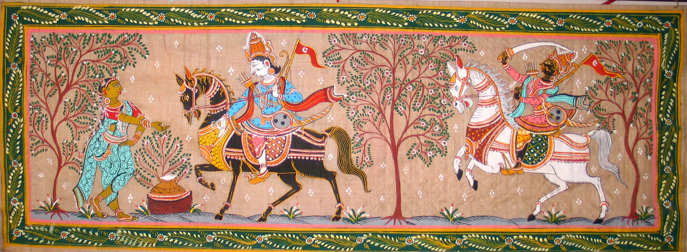
Pattachitra, a traditional scroll painting form from Odisha with a history dating back to 2500 years.
The subject matter of pattachitra paintings is mostly mythological episodes, religious stories and folklore. These paintings were originally substitutes for worship on days when the temple doors were shut. Commenting on how his source of livelihood has given him immense satisfaction as a noted artist of a dying art form. It is remarkable how the traditional patuas and chitrakars are clinging on to this tradition of making pattachitra despite the poverty it brings with it.
The most important aspect of the paintings is the accompanying music song , completing the entire narrative as a story.Chitrakars do not just paint, they also sing as they unfurl the scroll to audiences. These songs are known as pater gaan. The songs range from traditional mythological tales and tribal rituals to stories based on modern Indian history and contemporary issues like protecting forests and 9/11 attacks.
Vedartha Sangraha
Of the nine works that Ramanuja wrote, Vedartha Sangraha was the first. It was in fact a discourse that he gave in Tirumala. The title can be translated as ‘Essence of the meaning of the Vedas.’ Although the word ‘Veda’ is used in the title, the work is, in fact, about the Upanishads. There is nothing peculiar about this, because Upanishads are simply sections of the Vedas.
Jaimini wrote a Sutra for what is called the Karma Kanda section of the Vedas, but the Brahma Kanda is more important from a philosophical standpoint and Vyasa wrote Brahma Sutra on the Brahma Kanda portion.
The Vedas have statements that speak of bheda (several), abheda (One) and bhedabheda (several and One). In Ramanuja’s philosophy, all three are reconciled. They are not seen as contradictory but as complementary.
The charm of Chanderi
Originally woven exclusively for royals, the fine-spun cottons of Chanderi were as renowned as the muslins of Dacca. An indigenous variety of cotton was used in spinning to create a translucent 300-count fabric. Till the 1940s, Chanderis were characterised by an off-white base which was the natural colour of the yarn. Later, the weft cotton yarn was dyed, resulting in the famed pastels. Since the warp silk yarn was non-degummed, it did not lend itself to colour absorption and was left without a dye. However, evolving techniques have facilitated the dyeing of the silk yarn in the warp, resulting in darker colours augmenting the palette.
Chanderi is one of the well-known handloom city in India, chanderi famous for its saree, made with mix of cotton and silk also its one of the great tourist place in Madhya pradesh
How Kerala boy, 14, swims to school daily so his village can get a bridge:-Unique way of protest.
*We could not help but have to publish this , even though we know it has little utility from exam point of view.The story gives purpose to pursue a career in public service , so that No Arun has to swim everyday to get to school.
Publishing as is – (no editorial oversight) :-
Arjun Santhosh, a fourteen year old student from Kerala’s Alappuzha leaves home in the morning like any other student. In his uniform, with a bag. But unlike others he has a swimsuit and water goggles in his bag. While others wait for a boat, he jumps into the Vembanaad waters, swimming 3 km to his school in Poothotta.
He has been swimming to his school everyday for his villagers. A protest demanding a bridge for his village Perumbalam, an island in Kerala’s Alappuzha district.
Boats too small, too slow
“Usually boats are late and I get punished at school for being late. Some boats are very small. And there are too many people. It is a cause of worry,” says Arjun.
The Perumbalam panchayat houses more than ten thousand people. This ninth class student decided to join his villagers in protest when their 25-year-old demand for a 700-metre bridge was not met.
1.5 hours to reach mainland
“Transportation is a major problem. Last year close to 50 people died here due to medical emergencies… like snake bites for example. It takes about one-and-a-half hours to reach the mainland,” said Abhilash, a resident.
Arjun’s protest lasted 10 days for the authorities to acknowledge the villagers’ concern once again but no solid assurance have come their way yet.
Instead, the authorities have decided to send him a notice asking him to withdraw from the protest.
“He is a minor and it is dangerous to swim in this season. If something tragic happens we would be held responsible for not stopping him. Hence we decided to send him a notice,” said R Girija, collector, Alappuzha.
A bridge too far
“Yes, a bridge is a necessity here. We have six boats here which are in a very poor state,” said Shobhana Chakrapani, panchayat member.
Arjun has agreed to stop his protest hoping the authorities will now take a step towards building a bridge. But he warns them that if they fail, he will go back to taking the route less travelled.
Mineral from wet, hot volcano lava found on Mars, baffling scientists
Scientists are baffled by the discovery of a mineral on Mars that, on Earth, typically comes from extremely hot volcanoes whose lava was exposed to lots of ocean water.
A rock sample drilled by the Curiosity rover in the Gale Crater — believed to be the bed of an ancient lake — included tridymite, a silica-based mineral typically produced on Earth by powerful eruptions of volcanoes such as Mount St. Helens in Washington state.
That’s because on Earth, conditions that aren’t known on Mars are needed to produce tridymite.
Mount St. Helens erupts in Washington state. Mount St. Helens is a silicic volcano, producing lava rich in silicic minerals like tridymite.
While Mars has volcanoes, they’re basaltic volcanoes like those on Hawaii that produce a lava high in iron and magnesium and low in silica.
The volcanoes in the Cascade range of B.C. and the U.S. Pacific Northwest on Earth are a different kind, called silicic volcanoes. They were formed when the Juan de Fuca plate in the Pacific Ocean pushed under the continental North American plate, taking a lot of ocean water with it. As a result, the lava in the Cascade volcanoes contain a lot of silica — a mineral that forms in the presence of water and requires extremely hot temperatures to melt and recrystallize into a material like tridymite.